Table of Contents
2-2 Sedimentary Rocks
Read Chapter 6 in Physical Geology.
As described in the introduction to Chapter 6, sedimentary rocks make up the right-hand side the rock cycle, which involves the transportation, deposition, and lithification of the products of weathering and erosion. These products include sediments of various types that range from boulders to clay, and ions in solution. The resulting sedimentary rocks are known as clastic if they are made up mostly of rock and mineral fragments (i.e., clasts) or chemical if they are made up mostly of material that was carried to the depositional site as ions in solution.
Sediments are classified by size because their transportation by water or wind is primarily dependent on their size. Their classification, described in Table 6.1, is based on a doubling scale in which each category is twice as big as the one previous. The sand grain classes, for example, go from to , ¼ , ½, 1, and 2 mm. You don’t need to know or memorize the Wentworth Scale, but it is worth remembering this: everything smaller than mm is finer than sand (and particles that small don’t feel gritty between your fingers), and everything bigger than 2 mm is coarser than sand.
Completing Exercise 6.1 should help you to understand classification of grains. If you can visit a beach of some type, determine if the grains are sand-sized, or finer or coarser than sand. The grains may be different sizes in different parts of the beach. Take some extra time to determine if the grains are well rounded or not (which is a lot easier if they are bigger than sand). If you can’t get to a beach right now, think about some beaches or river bars you have visited, and try to remember whether the clasts were sand-sized, pebble-sized (up to about 6 cm), or bigger.
Figure 6.1.2 shows the forces on a grain of sand in water. As gravity forces it down, friction is the resisting force that pushes it up. If you drop a pebble and a grain of sand in air, the pebble will hit the floor first, but only by a fraction of a second. Drop the same pebble and sand grain into a metre of water, and the pebble will hit the bottom several seconds before the sand grain. In both cases, the gravitational forces are the same, but the frictional forces are quite different because water is so much more viscous than air. This principle is important because it is the rate at which particles settle through water (or air) that determines the extent to which they can be transported in flowing water (or wind).
Of course the other key factor in this regard is the velocity of the water (or air). The faster the water flows, the more turbulent it will be, which contributes to eroding sediments and keeping them in suspension. Also, the faster the water moves, the farther the suspended sediments will travel before they settle to the bottom. Look carefully at Figure 6.1.4 in the textbook to understand the transportation of (a) the larger sediments in a stream by traction and saltation, (b) the smaller sediments in suspension, and (c) ions in solution. Almost always, except at very low velocities, some particles are being eroded and some deposited at virtually every location along a stream (Figure 2-4).
Table 6.2 in the textbook summarizes the various types of clastic sedimentary rocks. Mudrock is dominated by silt- and clay-sized fragments, and if there is evidence of lamination (fine layering), it is called shale (Figure 6.1.8 [a]). Mudrocks are deposited in very low-energy environments like lakes and the deep ocean.
Sandstone is dominated by sand-sized fragments (Figure 6.1.8 [b]) in several varieties, depending on the types of grains and the proportion of finer material. Arenite (see Figure 6.1.6) is clean sandstone with no more than 15% silt or clay. Almost all sandstones are dominated by quartz. If quartz is greater than 90%, it’s a quartz arenite. If less than 90%, and if more feldspar is present than rock fragments, it’s an arkose. If rock fragments (such as sand-sized grains of volcanic rock) outnumber feldspar grains, it’s a lithic arenite. The same diagram applies to silt/clay-rich sandstones called wackes (it’s a German word, pronounced “vack-e,” but most students say “wacky”). Some sandstone examples are shown in Figure 6.1.7. Sandstones are deposited in a wide range of environments including rivers, deltas, beaches, the near-shore ocean, and deserts.
Coarse clastic sedimentary rocks are divided into two main types, depending on the roundness of the clasts. Granules and pebbles quickly become rounded if they are transported in water (e.g., a fast-flowing stream), and the resulting rock is called conglomerate (Figure 6.1.8 [c]). If the rock fragments are part of a slope failure—for example, if they tumble down a cliff—the fragments will still be angular and the rock is known as a breccia (Figure 6.1.8 [d]). Typically, conglomerates are deposited in high-energy rivers and sedimentary breccias (not to be confused with volcanic breccias) and are formed beneath steep cliffs.
Coal is deposited in swampy environments where the abundant dead organic matter can remain submerged in low-oxygen water for centuries or millennia until it is covered with more sediment. This typically happens on the floodplains of rivers that periodically change their course.
Completing Exercise 6.2 will help you to understand what is involved in describing and classifying sandstones and clastic rocks in general.
Chemical sedimentary rocks form when ions that have been transported in solution are precipitated as specific minerals or groups of minerals. For example, calcium (Ca2+) and carbonate (HCO3 -) are taken from sea water by various types of organisms (corals, molluscs, algae, etc.) and turned into calcium carbonate (e.g., the mineral calcite) that makes up shells and other structures (see Figure 6.2.1 and Figure 2-5). Fragments of these materials later accumulate to form rock limestone.
Although most limestone forms from the calcium carbonate created by marine organisms, in some cases, the carbonate is precipitated directly from water by strictly chemical processes to form material such as the ooids shown in Figure 6.2.3 (c) or the tufa shown in Figure 6.2.4.
Many other types of chemical sedimentary rocks exist, and all of the important ones are described and illustrated in the textbook. They include chert, banded iron formation, and evaporites. Please make sure you know how these types of rocks are formed. Note for registered students: You do not need to complete Exercise 6.3, since you did something similar in Assignment 1.
Section 6.3 deals with sedimentary depositional environments and sedimentary basins. Depositional environments include a wide range as is illustrated in Figure 6.3.1 and Tables 6.4 and 6.5. It’s important to make the distinction between terrestrial and marine environments. Terrestrial includes all freshwater environments such as lakes, swamps, and streams, plus glaciers and deserts; whereas marine includes everything that’s within the oceans.
Exercise: Look carefully through the rows of Tables 6.4 and 6.5 and make sure that you can see where each of these environments fits in Figure 6.3.1.
Most sediments that are deposited on land (e.g., in rivers or by glaciers) get re-eroded long before they can be turned into sedimentary rocks. Some of that re-erosion occurs within months or years, and sometimes it takes thousands of years, but even if it’s tens of thousands of years, that’s generally not long enough for the sediments to be lithified. Lithification, which is described briefly in Section 6.1, includes a range of processes that include the compression of sediment (from the weight of overlying sediments) such that all of the grains are touching, and the formation of cementing agents between the grains. These cements can include calcite, quartz, hematite, clay minerals, and various others, and it doesn’t take a lot of them to turn compacted sediment into hard rock, as is shown in Figure 2-7.
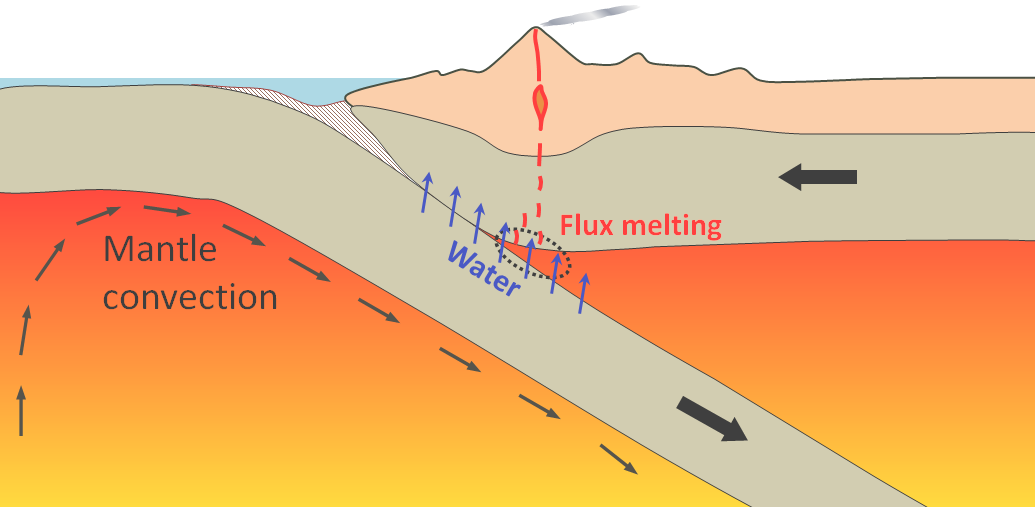
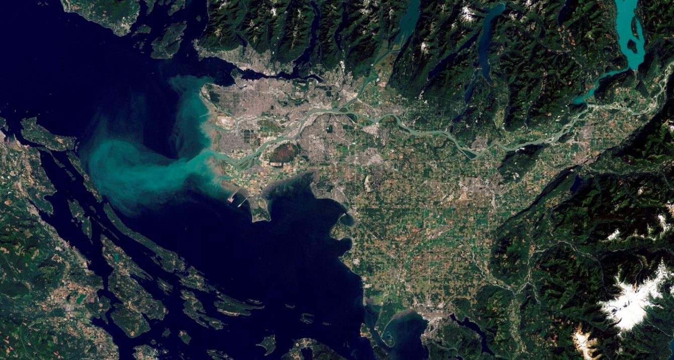
To be preserved and become sedimentary rocks, sediments have to last long enough to be buried deep beneath other sediments. This process almost always occurs within some type of basin, and the process typically takes millions to tens of millions of years. Most such basins are created by tectonic processes when parts of the crust get pushed up or pulled down during plate interactions. Some of the tectonic situations where this occurs are illustrated in Figure 6.3.2. As noted previously, the Strait of Georgia is a forearc basin (Figure 2-8). The Cretaceous Nanaimo Group sedimentary rocks of Vancouver Island, which are described in Section 6.5, were deposited in a forearc basin.
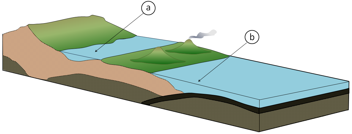
The following exercise should give you some practice in understanding the relationships between plate tectonics and the formation of sedimentary basins. Your Open Learning Faculty Member can check your answers or give you some help if you need it.
Exercise: Two sedimentary basins are depicted on the following perspective diagram. For each, indicate what type of basin it is and describe the mechanism of its formation.
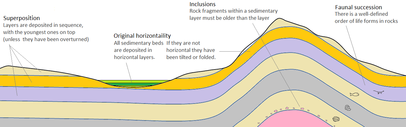
Section 6.4 includes a discussion of sedimentary structures and fossils, but it starts with a summary of the important principles that can be applied to the study of sedimentary rocks. These principles are illustrated in Figure 2-9. Make sure that you understand what they mean, and more importantly, how they can be applied to understanding sedimentary rocks.
Section 6.4 also includes a discussion of the importance of sedimentary structures to understanding sedimentary rocks and their depositional environments. Sediments and sedimentary rocks provide us with an extremely long (almost 4 billion years) record of the conditions on the surface of the Earth, which includes the conditions under which existing rocks were weathered, the types and distances of sediment transportation, the nature of the depositional process and the environment in which deposition occurred, and even the climate at the time.
Read Section 6.4 and then complete Exercise 6.4 to make sure that you understand how you can interpret these types of features.
In Section 6.5 of the text, we look at the systematic organization and naming of geological units. For the most part, this only applies to layered units—particularly to sedimentary rocks but also volcanic rocks, especially where they are interlayered with sediments. Make sure that you understand the hierarchy of classification in which the highest level is known as a group, and that groups can be divided into formations, formations into members, and in a few cases—where particularly detailed geological mapping has been carried out—members into beds.
Intrusive igneous and metamorphic bodies are not normally named using the group-formation-member convention. Instead, it is common to call an intrusive body a stock, batholith, or complex (for example, the Coast Range Plutonic Complex). A body of metamorphic rocks is typically also called a complex.
The example used in the text to illustrate the naming of geological units is the Cretaceous Nanaimo Group, which underlies much of the eastern edge of Vancouver Island, extends beneath the Strait of Georgia, and also is present in a few locations on the mainland. The sediments that make up these rocks were deposited in a forearc basin that was the precursor to the existing Strait of Georgia forearc basin.
Please answer the questions at the end of Chapter 6, and then check your answers in the textbook.